Last week, our CEO Sylvain Moulherat was invited to present our work on the subject at the Via Fauna technical seminar.
Via Fauna is a project launched in 2017 by the Fédération Régionale des Chasseurs d'Occitanie (Regional Federation of Hunters), which has led to the development of tools and methods for better integrating ecological connectivity into land-use planning projects and urban planning documents.
One of its major outcomes was the creation of the ORfeH database, which catalogues engineering structures and evaluates their potential use by wildlife to cross over or under transport infrastructure.
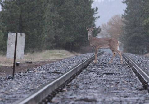
These data came at the perfect time for us: since 2018, we’ve been leading a long-term mission entrusted to us by SNCF Réseau, aimed at reducing wildlife collisions on railway tracks in Occitanie. The objective: to protect wildlife while also improving train service regularity and safety.
The first phase of the study, over the course of three years, involved identifying high-risk areas for wildlife collisions across the rail network.
Along five priority sections totaling 500 km of track, we simulated the movements of three species (wild boar, roe deer, red deer) using our SimOïko software. It was during this phase that we made use of the ORfeH database.
The simulation allowed us to estimate the likely number of animal crossings along the analyzed sections.
In total, 44 “hotspots” were identified and prioritized, with five undergoing detailed studies to determine the best mitigation measures.
For each of these five sites, workshops led to the design of several planning scenarios, which were then "tested" using SimOïko.
The simulation results helped evaluate the expected effectiveness of proposed structures (i.e. how much they would reduce crossings in risk zones), enabling the selection of the most cost-effective scenario for each site.
SNCF Réseau also expressed the need to establish long-term monitoring tools to measure the effectiveness of these mitigation efforts.
This second phase of the project, launched in 2022 for a minimum of five years, involves the use of camera traps installed in various areas where infrastructure improvements are planned.
The images collected are analyzed using AI through our Ocapi software, which automatically identifies target species.
This makes it possible to determine the actual frequency of animal crossings for each species, observe how this frequency changes over time, and ultimately assess the impact of mitigation measures on wildlife movement.